2009年5月12日星期二

1. Choose a region of Canada. (We have learned)
THE ARCTIC REGION.
2. Find a picture you like of this region.

3. Tell me about this region's climate, vegetation, topography. Use 5-8 sentences.


Climate:It's very cold and few rain.It is difficult to live.


Vegetation:Just has a little low bush.


Topography:There are many ice and cold sea.Also has very few land was covered by snow.And it is dangerous,coz the earth will collapse when ice was melt.

4. Find a picture to show this region's climate. Be creative.

5. Find a picture to show this region's vegetation. Be creative.

6. Find a picture to show this region's topography. Be creative.


2009年5月10日星期日

This is the last region we are going to learn about!We are going to have a test on Friday on all the regions we have learned!What is the Arctic Region?The Arctic Region in northern Canada is a combination of lowlands and mountains!Questions (You have 7 questions in total!)


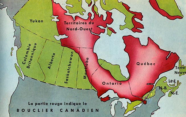
1. Find a map that shows you the Arctic Region in Canada. Explain what you see in 3-5 sentences.


It's in the north.By broken islands.It's N66°34 to N82°.


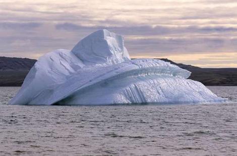
2. Find a picture of the Arctic region you like or don't like. Explain what you see in 5 sentences!


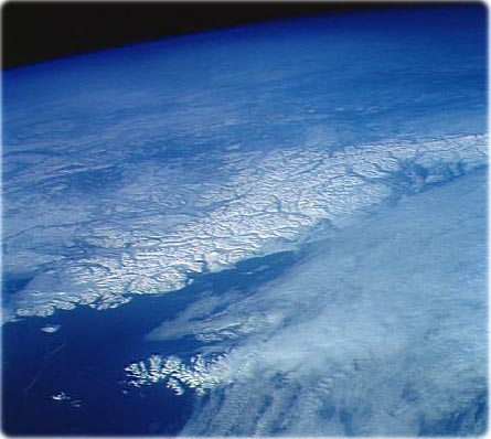
I like this picture,coz it is beauitiful.Anything is white.But i didn't like that region.It's difficult to live there or do any sightseeing.


3. The Arctic region's climate has long, cold winters and short, cool summers! There is very little precipitation in this region. What would your life be like if you lived here? Explain in 5-8 sentences.


NO!That realy.I didn't want to try anymore.And i don't know how did Eskimos live.Perhaps i will go there when i grow up to be a adventurer.


4. The Arctic region's vegetation include small shrubs, mosses and lichens.


a. Translate shrub into Chinese or Korean


shrub:灌木


b. Translate mosses into Chinese or Korean


mosses:苔藓


c. Translate lichens into Chinese or Korean


lichens:地衣


5. The Purple Saxifrage is a low-lying plant that grows in the Arctic region. Can you find a picture of this plant?


Great picture,isnn't is?I can't belive that this kind of flower can live in this terrible region.


6. Trees cannot grown on tundra.


a. What is tundra? Translate into Chinese or Korean.


Tundra:苔原


b. Explain what is it in English in 2-3 sentences.


That's a kind of climate.It has a very very thick cold permafrost.It's hard to live.But Polar bears live in there.


7. Find a picture you like of the Arctic tundra. Post it! Explain what you like about it in 3-5 sentences.

This is a picture of the Arctic tundra's night.I can feel it is cold.But the snow is realy beauitiful.


Bonus
1.Watch this video to learn more about this region:http://videos.howstuffworks.com/hsw/5847-canada-the-arctic-region-video.htm

2009年5月7日星期四

Western Cordilleran vegetation varies enormously from one side of a mountain to another. Some sides of a mountain get a lot of water and some don't!It is called the rain-shadow effect!Did you know?
On the most, windward slopes of the mountain. There are trees like the Douglas Fir, western hemlock, and western red cedar. Questions (There are 8 questions today!)
1. Find a picture of the Douglas Fir. Post it. Have you seen this tree?


Perhaps i have seen it,but i can't distinguish it.They looks like are the same.

2. How can you remember what this tree looks like and it's name?


I can't.But i have already searched it.It's Chinese name is 花旗松.Just like the tree what use in Christmas.

3. Find a picture of Western Hemlock. Have you seen this tree before?


I have never seen it.But is know that.This tree is very hard.And can life is strong.


4. When you look at a Western Hemlook, what is special about this tree. Tell me 3 things about this tree?
Go to this website for some answers! http://www.for.gov.bc.ca/hfd/library/documents/treebook/westernhemlock.htm


The tree is high.The leaves is triangular.Cedar nuts are long,not circle.


5. There are many mountains in this region. What do you think happens to the vegetation when we get higher up to the mountain? Can you guess?
The vegetation will be small.Coz it can reduce water evaporate.They must are cold-resistant.


6. In the southern part of the Western Cordillera region, there is less rain. If there is less rain, do you think the great evergreen trees will grow?


Yes.Coz the organisms to adapt with the surrounding environment that i learned on class.So the vegetation in there,must be able to tolerate drought.


7. The largest trees in the world exist in this region. They can be found in the United States because this region is very long and goes all the way down into Canada's neighbor!!! These trees are called "Giant Sequoias".


a. Find a picture of a Giant Sequoia you like. Explain why you like or don't like it in 3-5 sentences.


That's two pictures.It's realy amazing.Human is too small to compare with the tree.The tree is very high too.I can't describe accurate.


8. What did you learn today? Explain in 5-8 sentences. Be serious!!!!


I learned many kind of tree.Some are small some are huge.Diffirent trees have diffirent features.Some tree are cold-resistant and some are able to tolerate drought.


Bonus1. Can you find the largest tree in the world?


Yes.It is Giant Sequoia.


a. Find a picture. Post it.


b. Where is it?
In California.


c. How big is it? What are the measurements?
It's 311 feet.

2009年5月5日星期二


Questions (There are 7 Questions)Please answer the questions with the number of sentences I tell you to. This is important because you need to practice your English.


1. Find a photograph of the Western Cordillera Region. Post it.


2. Find a map of The Western Cordillera region.Explain what you see in the map in 3-5 sentences.


There are many mountains in the middle of the Western Cordillera.The mountain is long.It cut the region to two part.There are lots of lake in the west part.The Canta cruz is the biggest province.


3. Find picture you like of the Rocky Mountains.Explain why you like it in 5-8 sentences.


The first is the picture is beauitiful.On the top of the mountain is snow because there is too high to melt.The Rocky Mountains is very dangerous.The mountain is crook and steep.I can't find any ways to go the top.It isn't good for climb but we can enjoy it.


4. The Rocky Mountains are fold mountains.


a. How are fold mountains made? Use your OWN words to explain this process.Go to this website to find the answer:http://library.thinkquest.org/05aug/01406/fold%20mountains.html


It made by crust moving.Tow piece of crust shoved and some crust go up then become a fold mountain.


b. What are some other examples of fold mountains?


Himalayas mountain,Caucasus Mountains and so on.


5. Find a photograph of another fold mountain in the world. Post it.Explain what you see in 3-5 sentences.

This is Himalayas mountain.I can see the top of mountain that the highest mountain called Everest.The mountain line is very long that higher than the clouds.


6. There are a lot of mountains in this region, would you want to live here?Tell me three reasons why or why not.
NO.There is difficult to live people.The oxygen is little.The sunshine is too strong to bear.But the temperature is low.Pressure is too low that when the water reached the boiling will be 70 degrees.
7. What did you learn today? Explain in 5-8 sentences.
I knew how are the flod mountains made.And i see many kinds of mountain's picture.Just linke the Rocky mountain.It is realy dangerous.I discover the high mountains always have some snow on the top.

2009年5月3日星期日

The Canadian Shield is more than 2 billion years old. It consists of great volcanic mountains that were leveled by millions of years of erosion. It is the geographic foundation of Canada covering more than half of its surface area.

1. Find a map of this region. Which provinces are in this region? (IF you don't know what your map is telling you, WDO NOT RITE I DONT KNOW! ASK me or a friend!)


Territoires du Nord-Quest,Minltoba,Ontario,Qubec.


2. Translate erosion. What is erosion? Explain in your own words.The climate of this region varies greatly. There are colder winters in the north.
Erosion:It means sth. was already bad.It is reducing.

3. Why do you think the climate of this region will vary? Explain in 3-5 sentences. Look at the map of this region and think about it.
Coz the southern and the northern have a big diffirent of longitude.The northern is more closer to South Pole so it's very cold.The southern is close to equator so it is hot.And some cities are near by the sea.

4. The vegetation of this region is mostly boreal forest. What is special about a boreal forest? Explainin 3-5 sentences.


They'er good at living in the cold climate.Their's lifes are strong.But they also died by hot climate.


5. Find a picture of the Canadian Shield. Explain why you like this picture in 3-5 sentences.


Perhaps this picture was took by the satellite.I can see the Cannadian Shield intuitive.And i can see many cities and mountains,i also can see a little sea surface.


6.There is a lot of mining in this area. The Canadian shield is sometimes called a "mineral storehouse" because it has a lot of valuable minerals like lead, copper, gold, zinc and nickel.
a. Find a picture of lead. Post it.


b. Find a picture of copper. Post it.


c. Find a picture of gold. Post it.


d. Find a picture of zinc. Post it.


e. Find a pciture of nickel. Post it


7. If you were the owner of a mining company, why would you want to come to this area? Tell me at least 2 reasons.
If i have a company.I think i won't come this area.Coz it is too far to collect.The cost is too dear.

When you are finished, you can have free time.

2009年4月28日星期二

1. Are there geographical regions in China or Korea? Explain in 3-5 sentences.

Plateau,Hills,Plain,Basin and Mountains.Qing zang Plateau is the highest Plateau in the world.North China Plain is the most important place in China.Qaidam Basin is too hot to live.But it's a large suaeda.


2. Post 3 pictures of China's or Korea's regional geography. It can be photographs. Explain each picture in 5-8 sentences.


This is North China Plain.Terrain is flat.And the cities are near by the Pacific Ocean.China's capital Beijing is in there.The traffic is facilitate. It good for business.


It's the picture of Tibet Plateau.There are some white where nival because it's too cold to let snow melting.Under the Tibet Plateau is Mountain Everest.


Just yellow.It means only the desert and desert.Everwhere is sand.There is short of water and plants.The environment is terrible.


3. What have you learned about regions so far? Explain in 5-8 sentences.
I know many kinds of regions.The continent,the ocean,the gobi,the desert and the mountain.The continent is a very large area of land.The ocean is bigger than sea.The gobi is a special desert.The desert is made of sand.The mountain is the mountains,the hills and the vallies.

2009年4月27日星期一

1a. Translate ocean into Chinese or Korean.

ocean:海洋


1b. Which Canadian province is closest to the Pacific Ocean?

The British Columbia.


1c. Which Canadian provinces is closest to the Atlantic Ocean?

The Newfoundland.


2. Find a picture of the Pacific Ocean you like. Explain why you like it in 3-5 sentences.


This map is good to find Continental Shelf or Trench.It can tell us how high the mountain and how low the basin.The other reason is this map's perspective is large,so i can see many many continents and the others ocean.It aslo can tell us lots of information about the earth.


3. Find a picture of the Atlantic Ocean you like. Explain why you like it.in 3-5 sentences.


This picture is realy amazing.It not only a map but also a art.It's uneven.I can see the mountian. And i can find some small waves.It's realy beautiful.


4. Why would the Interior Plains region's climate be affected by the ocean. What does the ocean do for the climate? Explain in 5-8 sentences. Look at your past lesson.

Because the oceans' thermal volume is more than the continents.So the temperature of the oceans is always diffirent with continents.When the sea breeze coming,it will meet the continent thermal collision.This is Monsoon.

It can have a temperature difference between the four seasons, but rainfall.


5. What continent is the Interior Plains region on? Explain in 5-8 sentences.

Eastern European Plain, the West Siberian Plain in Asia, South America, the Amazon and La Plata Plain Plain, the Great Plains and North America.

6. Where is the Interior Plains region on this continent? What provinces are in this region?

Rocky Mountain west, east of the Mississippi River.The Yellowknife and the Winnipeg.


7. What did you learn today?

I knew lots of geographical knowledge.That is realy practical.I found many Interior Plains and oceans.Of course i learned many many words about geography.